Last February 20th, I hiked and skied 12 laps on Mt. Glory. 19,638 feet climbed with skis on my back and 19,638 feet skied to raise money for Camp To Belong. It's snowing again and I'm ready for the 2nd edition! Click the logo for more info and ways to support camp!
Camp To Belong - Elk Mountain Grand Traverse
We're racing the Elk Mtn Grand Traverse this March, a 40 mile ski race across the roof of Colorado in the middle of the night! Click for updates on our training and fundraising progress!
Peaked Sports
Driggs, ID
Wednesday, December 24, 2008
HAVE A MERRY CHRISTMAS YOU WILL!
And while it's Christmas, let me share with you the song that's been playing over and over in my head ever since I heard it for the first time two weeks ago. No matter how hard I try, it just won't go away. Merry Christmas!
(be sure to pause the music player at the bottom of the screen before clicking the link)
After the run with Trevor on Sunday, I drove south to Oregon City to meet my parent's at my sister's house so we could all go together to Corvallis to see her stepdaughter sing with the OSU Chamber Choir. On Monday, I bummed around Portland and visited my Buddy Joe and his family that evening and had a couple other friends, Ben and Kay, stop by as well so it was great having everyone together finally! Good to catch up. I miss you all!
On Tuesday, I was back in the Gorge for another long run. This time, starting at Herman Creek TH and running upcanyon
to Casey Creek Trail,
up to Nick Eaton Ridge,
then up to Mt. Defiance,
over to Gorton Creek Trail,
and back down to Herman Creek stopping only to adjust clothing, take photos, and have some mystery stew with the old mountain hermit that lives in this cabin in the woods. (Felt kinda funny afterwards... I wonder what was in the stew...?)
I didn't get to do the "long option" on this route because the "short option" had already taken longer than I thought (another 6 1/2 hour run), but I was totally satisfied with it. Felt great the entire time. I love the extra boost of horsepower at sea level!
2:45pm MST: Left Driggs to begin my drive west to Portland with Buddy riding co-pilot.
Saturday, December 6th-
1:15am PST: Arrived in Portland at my parent's new house after 11 1/2 hours of driving (including a 1/2 nap at a rest area outside of La Grande, OR).
2:30am: Went to bed after chatting with mom and dad.
In the morning, at 8:00am, I woke up, had breakfast and went out for my favorite Portland city run at Mt. Tabor. (*Note: My advice is to not attempt an intense 1 hour long interval stair workout the morning after sitting in a car for half a day then getting 5 1/2 hours of sleep. I felt like a slug and cut the run short. No more stairs!)
That evening, I stopped by to briefly visit my buddy Joe's parents, then headed over to Trevor's place in Hillsboro to have dinner with his fam and stay the night there for an early run in the gorge the following morning. Had a great time hanging out. Already looking forward to seeing you all again next time I'm in town!
By10:30pm I was Snoozin.
Sunday, December 7th-
We woke up at 5:00am and headed out the door. By dawn, we had arrived at Eagle Creek TH and we quickly got our gear together and set off. Task #1: Find the Buck Point trail at the back of the campground at the base of Ruckle Ridge and begin our ascent from elev. 100' to 4,000' in 3 miles. It took 2hrs, 15 min to reach Benson Plateau. Then it took a half hour for me to finally figure out our correct route after bumbling around traipsing through the woods from my inability to remember the way. (The last time I did this route was about ten years ago)
It took us an hour fifteen to cross the plateau, meet up with the PCT and follow it south for 4-5 miles until we reached the shores of majestic Wahtum Lake.
We were completely encased in heavy white misty clouds. As you can see, visibility was minimal.
In another hour fifteen, we arrived at the upper junction with the Eagle Creek Trail. This is where we really began to notice the rain that had begun. Up until this point, things had been damp, but not wet. Now we were getting wet. Really wet. (This stretch is also where we crossed paths with three teenage-looking kids coming up the trail from the other direction. 2 boys, 1 girl, all wearing ponchos. At this point, they were probably 12 miles out from the trailhead at Eagle Creek. None of them had backpacks. If they were heading to Wahtum Lake and back, that'd make for about a 30 mile + day of hiking. We saw no camps set up along our route. I hope they knew what they were doing and made it back ok.)
This was a perfect example of typical Oregon rainforest. As it began to rain harder, my camera got foggier and foggier.
It took another hour fifteen to arrive back at the car after descending Eagle Creek and passing by all the waterfalls along the way. We also encountered about 20-25 hearty Northwesterners and 5-10 dogs out braving the cold, drenching rain on their hike up the trail.
Total time was almost exactly 6 1/2 hours. Mileage? Somewhere between 20-25 miles.
Trevor enjoys dancing jigs in the rain whilst out running trails.
I'm off to Portland tomorrow. Got a few days off work and a Saturn full of gas and I'll be hittin the highway heading west across Idaho round 2pm which should get me into Portland round midnight (Pacific Time). Ugh... more time sitting in a car.
I'll be visiting family and friends and I've also mapped out two routes I'd like to run in the Gorge while I'm there.
Tell me these don't look like a couple o' dang-fun-lookin 'ol routes!
Start at Eagle Creek TH. Up Ruckle Ridge to Benson Plateau. South across Benson Plateau to the PCT and continue south to Wahtum Lake. Around Wahtum Lake and west down to Eagle Creek. Down Eagle Creek back to TH. Mileage: Approx 25 miles
Start at Herman Creek TH. Up Herman Creek Trail to Casey Creek. Up Casey Creek (2900 ft in 2.1 miles) to Nick Eaton Ridge. South on Nick Eaton Ridge to Green Point Ridge. Around the NE edge of the ridge and under to North Lake, then east up to Mt. Defiance (4960 ft). Backtrack SW all the way to Wahtum Lake, then north down Herman Creek. Finish #1 is to go back up Casey Creek to Nick Eaton Ridge, then descend Nick Eaton Ridge to the TH. Finish #2 is to simply run out the Herman Creek Trail. Option #1 is preferred, but it depends on how I'm doing on time and how I feel. Mileage: 35 miles?
And so it began, on Thanksgiving Day, that Jen and Mike and I embarked on our southward journey for the weekend. Destination? South Rim of the Grand Canyon. But first, we were stopping for the night at Jen's cousin's house in Salt Lake City. Then, after waking at 6am, and a brief stop at Best Buy to purchase a new battery charger for my camera (which was horrible timing due to the 6:30am consumer-madness on the day after Thanksgiving. That place was infested with a ridiculous amount of impulse buyers. And they'd been open since 5am! WHAT?! But that's a whole other issue...), sigh..., we finally hit the wonderful I-15 and promptly accelerated up to 88.8 mph to begin our travel through the space-time continuum. Unfortunately, our flux capacitor was malfunctioning so we had to settle for the old fashioned method of travel. We need to get that thing fixed.
Upon arriving at the South Rim, we noticed small traces of snow alongside the road, evidence of the recent snowstorm that blew through the region on Thanksgiving Day. Just missed it! We rolled in around 3:30pm to mostly sunny skies and temps around 45 degrees. The forecast was for improving weather. More sun and more warm.
We dropped Mr. Fuzzy Buddy off at the kennel, set up camp while we still had light, drove into Tusayan for the traditional pre-run pizza dinner at We-Cook-Pizza-etc, then finished packing our things for the early start in the morning.
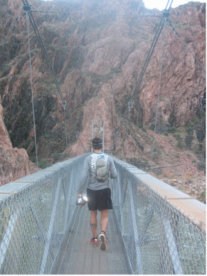
We woke at 5am and left camp on foot at 6:05. The route was to begin from the South Kaibab TH (a 4-5 mile jog from camp), descend to the river, cross over to Phantom Ranch, go up the North Kaibab Trail to the North Rim, turn around and go back to Phantom Ranch, cross over to the South Bright Angel Trail, and ascend that back to the South Rim where we would have a 1.5 mile jaunt back to the car. Jen's plan was the same except without the out-and-back to the North Rim. This way, we'd get to see more of the canyon (especially for Mike and Jen cause they'd never been there before), and this would leave a shorter distance back to the car at the end of the day.
We all left the South Kaibab TH at 7:10. From there, everything went almost perfectly.
Mike and I were down to Phantom in 1:45. Roaring Springs in 3:45.
North Rim in 6:00.
Back to Roaring Springs in 7:30.
Back to Phantom Ranch in 9:30.
And 3.5 hours later, at 8:10pm, we were standing on the South Rim.
Total time: 14 hours.
Trail time: 13 hours.
Total distance: 50-51 miles.
Trail distance: 46 miles.
Nutrition*:
3 Clif Shot Bloks @ 200 cal ea = 600 cal
2 Clif Shot gels @ 100 cal ea = 200 cal
8 PowerBar gels @ 110 cal ea = 880 cal
4 GU gels @ 100 cal ea = 400 cal
1 Hammer gel @ 90 cal
3 LARA BARS @ 200 cal ea = 600 cal
2 Clif Kid Organic Twisted Fruit (Yummy!) @ 70 cal ea = 140 cal
1 bagel @ 200 cal
2 funsize Snickers Bars @ 100 cal ea = 200 cal
Total calories: 3310
12-13 bottles of water @ 20 oz ea = 240-260 oz
*I had planned on running with a multi-hour bottle of Hammer Nutrition Perpetuem as well as two bottles of Sport Quest Carbo-Pro, but I mindlessly left it all at home which explains why my caloric intake was a bit on the light side. 'Way to go smart guy!' So, I guess this was a good test to see how my body held up when using straight water and also to see how my body would react to a rather low fuel supply while out there. I ended up with zero food left and I only had to bum one Power Gel off Mike about an hour under the south Rim before we finished so apparently it wasn't much of a problem.
We had zero problems out there sans for a brief, 5-10 minute stop for Mike to tend to a developing sad blister. Back at the South Rim, we met up with Jen at the Bright Angel Lodge for some much needed food and I devoured a burger and a half, fries, and two cokes in 9 1/2 minutes. And then, as soon as I was done, I began to nod off whilst sitting in the restaurant booth. Time for bed. Unfortunately, the shower schedule had just been modified to winter hours and closed at 6pm so it was a not-so-fresh-and-clean feeling that night. Yuk. But we got up at 7am the next morning, had some food, had a shower, packed up camp, and went off on a quick photo shoot posing in front of the Grand Canyon in our bikinis. Rawr...
It's turkey time! (sorry turkey). Hope everyone is having an absolutely super Thanksgiving weekend. My Thanksgiving weekend is just getting started. After a brief 40 minute jog this morning, I'm now getting ready to head down to Montpelier, Idaho with SuperJen to spend Thanksgiving day there with her family. Then, after dinner, we're driving to Pocatello to pick up MikeE and head south to Salt Lake City for the night. Friday morning, at dawn, we'll load up and continue south to our destination: South Rim of the Grand Canyon. On Saturday, MikeE and I will begin our Rim-to-Rim-to-Rim route: Start at our campsite in Mather Campground, then jog a few miles east to the South Kaibab Trailhead, down South Kaibab trail, cross the Colorado River, up to the North Rim, back to the Colorado River, across and up the Bright Angle Trail back to the South Rim and back to the car at the campground. Total mileage should be right around 50 miles.
I feel more prepared this year. I've kept up some deceent training this fall spending alot of time on the bike and also doing some periodic long trail runs. Last Sunday, MikeE and I had planned on doing the Boundary Trail, a 35 mile loop just south of Pocatello, until he got called into work for an emergency disaster and left me to do the loop solo. It ended up taking me 8 hours and the final 10 miles were BRUTAL!!! A series of 5 or 6 ravines 500 feet deep that the trail goes down into and crawls back out of. Trail surface was rutted and littered with fist sized rocks everywhere. Ugh!
But it was a great training run prior to this weekend's run in the G.C. My hope is that this will prevent my calves from wanting to pop off my legs and debilitate me for days afterward. We shall see.
Wait, that's chickens that can't fly. Turkeys can fly, can't they? I can't fly. And I'm a turkey. At least that's what people tell me.
"So, Trevor, what are your plans for Thanksgiving? Going to see your family?"
"No, actually, I'm headin down to the Grand Canyon for Thanksgiving weekend."
"Oh, really? Wow... Why the Grand Canyon?"
"Well, it's kinda become a Thanksgiving tradition of mine. I've gone down there the past two years on Thanksgiving weekend to run across it and back and it's just become tradition."
"You turkey."
So you see, if this turkey could fly, then maybe I wouldn't have to run the 24 miles across on trail and instead fly the direct 10 miles across to the North Rim and back. Flight would be a tremendous benefit to this bird. But then again... I'd miss out on everything to experience whilst on ground. The flora, the fauna, the smells of the mule train an hour after they passed down the trail. Nah, give me my two feet and I'll gladly run, hop, skip, and skitter my way along the trail for 13 hours.
And although I'll have different company this year, the tradition lives on.
Thanks, Meghan, for suggesting two years ago what I thought at the time was a ridiculously impossible idea.
"WHAT?! Are you nuts!? Run across the Grand Canyon?! AND BACK?! In one day?! Hah! Yeah right. There's no way I could do that. And besides... Why?"
7. Ultimate Direction Handheld Bottle - The finger loops are essential when adjusting gear with one hand and holding both bottles using two fingers on the other hand.
8. Black Diamond Spot - It lights up the night, can be worn around the waist for better terrain definition and it weighs next to nothing.
9. Nathan Hydration Race Vest - Practically weightless at 4oz, it holds my Golite windjacket, cell phone, camera, and four gels in the front pockets, and an extra water bottle, MSR Hyperflow filter, lightweight gloves, and eight more gels in the rear pocket.
10. MSR Hyperflow water filter - This little beauty can pump out 1 liter of clean water every 30 seconds and it weighs 7oz. Slurp!
For a while now, I've been thinking about posting a list of the gear I use and love while out galavanting around in the mountains. I've just never gotten around to actually doing it. So, without further adieu, from the bottom up...
1.
Montrail Streak
The Streak by Montrail is designed for use on a variety of surfaces from rock and mud to grass and dirt. This lightweight and responsive shoe is designed for the trail runner with a need for speed.
Features: Multi-directional outsole design offers exceptional traction in every direction. Gryptonite “sticky rubber” outsole offers great traction on wet and dry surfaces, combined with outstanding durability. Trail Shield protects the foot from trail debris. Vapor-Response midsole material is both lightweight and responsive. Upper materials are lightweight and breathable. Weight 11.7 oz 0,33 kg
2.
Injinji Tetrasock - Outdoor Series
As your feet face the elements, the Outdoor Series tetratsok is an interface system specifically designed to perform and adapt to any type of terrain. Engineered with AIS:technology and constructed with Injinji’s exclusive natural wicking Nüwool™, the tetratsok provides exceptional comfort and performance unlike any other athletic wool sock.
3. Dirty Girl Gaiters
Next year, I wanna start runnin with scissors
4. RaceReady Shorts
And they even have a skirt model now for all you fashionista trail runners out there. Yeah, you know you want one. (I might not look too bad in one of these)
4. Smartwool shirts
SmartWool Microweight Crew Shirt - Long-Sleeve - Men's Wear the SmartWool Men's Microweight Long-Sleeve Crew Shirt for cool- or warm-weather aerobic activities or as a next-to-skin base layer. SmartWool's porous natural fibers move moisture while it is still in vapor form before it has a chance to condense on your skin; you stay drier and more comfortable throughout your entire workout. By comparison, synthetics transport moisture after it condenses, which means you must visibly sweat before any moisture management begins. SmartWool fiber adaptabls to a broad range of conditions, keeping you warm in winter and cool in spring. This naturally anti-microbial shirt features a crew neckline, chafe-reducing flatlock seams, and a body-hugging fit. Bottom Line: It might be Microweight, but it's big on performance.
5. Golite Ether Windshirt
Ultra-lite, extremely breathable, wind resistant, and water repellent, the full-zip Ether hooded wind jacket will come in handy when wind or weather pepper your next outing. 4 oz. and it packs down to the size of two cliff bars.


 Start at Herman Creek TH. Up Herman Creek Trail to Casey Creek. Up Casey Creek (2900 ft in 2.1 miles) to Nick Eaton Ridge. South on Nick Eaton Ridge to Green Point Ridge. Around the NE edge of the ridge and under to North Lake, then east up to Mt. Defiance (4960 ft). Backtrack SW all the way to Wahtum Lake, then north down Herman Creek. Finish #1 is to go back up Casey Creek to Nick Eaton Ridge, then descend Nick Eaton Ridge to the TH. Finish #2 is to simply run out the Herman Creek Trail. Option #1 is preferred, but it depends on how I'm doing on time and how I feel. Mileage: 35 miles?


 But it was a great training run prior to this weekend's run in the G.C. My hope is that this will prevent my calves from wanting to pop off my legs and debilitate me for days afterward. We shall see.


 MSR Hyperflow water filter - This little beauty can pump out 1 liter of clean water every 30 seconds and it weighs 7oz. Slurp!


